PROJECT Cemetery Locations

cemetery projectProject leaders Peter and Beverley Moss
The Project is an initiative of the Genealogical Society of South Africa (GSSA).
Description
Technologies such as Google Earth and GPS (global positioning system) coordinates make it easy to keep track of cemeteries already recorded/not and farm cemeteries that are otherwise difficult to locate.
Once set up and loaded with the appropriate .KMZ file available on the Genza website, Google Earth shows cemetery locations relevant to the cemetery related projects and indicates their position with an appropriate icon.
Deliverables
Two sets of information (two perspectives) are available via Google Earth:
  • GSSA Cemeteries (indexed cemeteries)
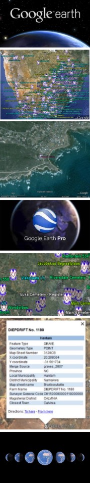
Google Earth opens with a high-level view of Southern Africa showing all the GSSA cemetery locations (i.e. all cemeteries that have been recorded), with a GSSA icon.
  • 50K Cemeteries (unindexed cemeteries)
The 1:50 000 topographical maps of South Africa show thousands of cemeteries marked as “+”. Files containing these points were created, indexed by location and farm name. These files were narrowed down to “+” marks representing cemeteries not yet recorded by the Cemetery Recording Initiative.
For each of these perspectives the location file (KMZ) is maintained monthly, which can then be interpreted by Google Earth.
Invitation
You are welcome to use these map enhancements; they are available to the public free of charge via the Gneza website
Contact
Peter and Beverley Moss via This email address is being protected from spambots. You need JavaScript enabled to view it..
Action
Set up to load and use Google Earth (GE).