Welcome to the GSSA 50k Cemetery Search Project

Data file last updated: 30 November 2020 with 13021 entries
The 1:50000 topographical maps of SA show thousands of cemeteries marked as “+”. Walter Smit, at the suggestion of Peter Silbernagl, has created a .kmz file of these points, also indexed by location and farm name. This .kmz file can be read using Google Earth, and clicking on the “+” mark opens a dialog box which gives farm name, GPS coordinates, etc.
The “+” marks represented by the existing cemeteries already “done” by the Cemetery Project have been deleted from this file if closer than 200m, so when loaded into Google Earth this new image only shows previously unknown cemetery locations. This is ideal for planning cemetery recording.
Download the GSSA 50k Cemetery Search File (.Kmz file). If you do not have Google Earth on your computer, you can download the software free from http://www.google.com/earth/
What does the map show?
|
|

|
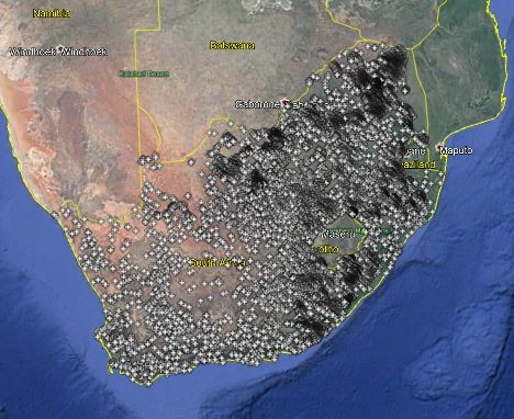
The map opens with a high level view of Southern Africa showing all the 50k cemetery
locations. The standard features of Google Earth can be used to zoom in or out, rotate the image, or fly to various coordinates.
Places of interest shown in the default Google Earth maps also assist with navigation.
Both the “50k” and the “Cemetery Initiative” .kmz files can be loaded into Google Earth at the same time.
|
Cemetery Name
|
|

|
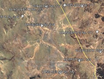
By zooming down in the general area of interest, the icons separate and the cemetery or farm name pops up next to the Cemetery mark
|
The Pop-up dialog box
|
|
 |
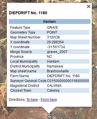
Clicking on the position “+” loads a popup window with various information, including::
-
Farm Name
-
Map title
-
GPS Coordinates
-
Nearest town
-
Magisterial District
-
Province
-
Nearest town
-
etc
|
Planning your trip
Having decided which area/ farms to investigate, make a note of the GPS locations and how to arrive there.
You will need:
-
Hat and sun protection
-
Camera set to take photos at least 2MB in size
-
GPS instrument set to WGS84 (Hartbeeshoek), with intended coordinates pre-loaded
-
Take a view of the cemetery entrance and an overview as well as each headstone
-
Brush and baby powder for cleaning up and clarifying headstones, also secateurs
-
Remove grass etc that obstructs the view of the headstone
-
Be aware of security, never go alone
-
Ask the farmer’s permission to visit the cemetery and take photos.
-
On completion send photos to Riana le Roux at This email address is being protected from spambots. You need JavaScript enabled to view it. quoting the farm name and GPS coordinates
-
DO NOT change the captions on the photographs, just send “as is”
Contact
Riana le Roux This email address is being protected from spambots. You need JavaScript enabled to view it.
Peter and Beverley Moss This email address is being protected from spambots. You need JavaScript enabled to view it.
Published - 30 Nov 2020 | Hits on this page - 36 | Files Downloaded - 8


